A Little History
Dedicated and passionate individuals and organizations around the world work hard to make sure our outstanding natural spaces remain intact. In the Creston Valley, we are fortunate to have a rich history in conservation. Many people, too many to name, were instrumental in promoting the conservation and protection of the diverse landscape we now call the Creston Valley Wildlife Management Area.
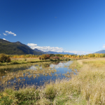
The history of the landscape and water regime in this valley is a fascinating and complex story in itself. High in the Rocky Mountains, the Kootenay River begins its journey, carving a route through the Rocky Mountain trench into Montana before making a wide loop through Idaho and then heading north into B.C., flowing into Kootenay Lake before draining its way into the Columbia River near Castlegar. The river basin once formed 70 kilometers of wetland habitat, approximately 8-10 kilometers wide, from the south end of Kootenay Lake down to Washington State, where waterfowl congregated in large numbers, especially in the spring and fall.
It was in the mid 1880’s that attempts were first made to alter this naturally existing marsh and floodplain. The annual flooding of the Kootenay River was an obstacle to the development of agricultural lands in this fertile valley in the 19th Century. Dykes were established and a grand idea of diverting the Kootenay River into the Columbia Lake and river system near Canal Flats was initiated but never came to full fruition. In 1894, a record flood destroyed the dykes that were already established and flooded the entire area in the Creston Flats. Later, the dykes were reconstructed and rock was blasted to widen the outlet where the Kootenay River flowed out of Kootenay Lake near Nelson. This changed the water flow pattern, allowing the reclamation of the flats for agriculture.
From 1884 until 1942, many applications and attempts were made for the reclamation and development of water power in the valley of the Kootenay River. Interestingly, it wasn’t until 1942 that the mention of the protection of any of the area for wildlife conservation was made. In 1942, concerns were raised and heard regarding the interests of wildlife in response to an application for land reclamation in the Duck Lake Area. The application was tabled pending engineering and biological studies. Dr. James Munro, of the Canadian Wildlife Service, was commissioned to do a biological study and he presented his findings in 1947, stating that the “Kootenay Flats constitute the largest and most important resting and feeding ground for waterfowl in the interior of British Columbia”.
Munro issued a report entitled “A Plan for the Development of Duck Lake Wildlife Management Project” where he outlined, in general, procedures, biological controls and administrative ideas. In 1960, the B.C. Wildlife Federation and the West Kootenay Association of Rod and Gun Clubs delineated the Creston Valley Wildlife Management Area when they applied to purchase all surrounding Crown lands around Duck Lake for wildlife conservation. Their offer was rejected, but their efforts continued through various hearings, studies and surveys before the Creston Valley Wildlife Act was passed in March of 1968.
Photo of the construction of the Interpretive Centre during the flood of 1974-75
The Act delegated a Management Authority to manage the Creston Valley Wildlife Management Area (CVWMA), a 7,000-hectare (17,000-acre) area of provincial Crown land located along the Kootenay River system. Now that the area was protected, efforts focused on turning the flood plain into productive wildlife and waterfowl habitat. With the support of Ducks Unlimited, BC Hydro, local and regional wildlife groups and federal and provincial government grants, the dykes that were intended to drain the marshes were expanded and modified to control the wide seasonal variation in water levels and create much needed waterfowl nesting and rearing habitat.

